
Drone Thermal Imaging
Drone Thermal Imaging Surveys From The Experts In Cambridge
- Building Heat Loss Surveys
- Roof Moisture Ingress Investigation
- External Cold Spots Detection
- Solar Array Surveys
- Livestock Auditing
- Wildlife Observation and Conservation

What is Thermal Imaging?
Thermal imaging, also known as infrared thermography, is a non-invasive technique that uses specialised cameras to measure temperature differences on various surfaces or objects.
Every material above absolute zero emits infrared radiation, or heat, which thermal cameras detect and convert into visible images. These images clearly illustrate temperature variations and highlight areas that are significantly warmer or cooler than their surroundings.
Because it does not require physical contact, thermal imaging is ideal for inspecting difficult-to-access or sensitive areas. It is especially valuable in applications such as detecting energy loss in buildings, locating electrical faults, and finding hidden water damage. By identifying subtle temperature anomalies, thermal imaging offers an efficient, cost-effective way to pinpoint problems before they become major issues.
In agriculture it can
help farmers
track livestock inventory by detecting the heat signatures of animals scattered over large or remote areas.
High Resolution Radiometric Photos
And Thermal Video
SkyTech Cambridge uses the latest thermal imaging technology, fully integrated into a purpose built drone, with an industry leading 640 x 512 high resolution sensor to produce high quality and reliable thermal images and video.
Images captured are fully radiometric which means that every pixel in the image contains a temperature value. This allows for more detailed post-capture data analysis and flexibility.
Thermal drone inspections can be conducted safely in confined and difficult to access areas both internally and externally; complete darkness; cold weather and remote locations. Deployable in under a minute and with a flight time of up to 45 minutes per battery - a quick response is assured to capture the data that you need.
Traditional handheld thermal devices are an invaluable tool for many reasons, however they are limited by the fact that they can only be used by an operator on the ground. The same technology is now operational on our dedicated thermal imaging drones which provide unrivalled access to buildings and infrastructure previously deemed too challenging to inspect.
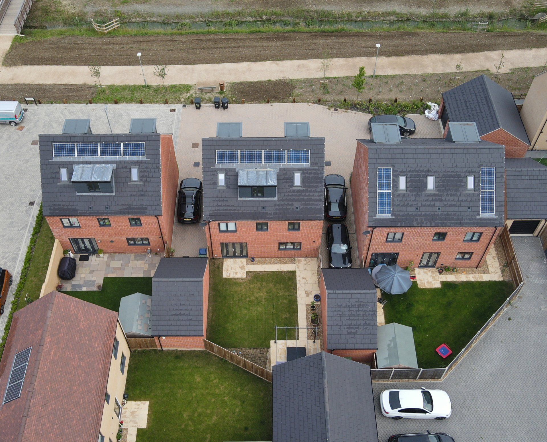
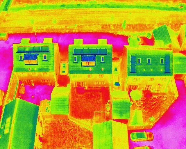
Thermal Imaging Survey For Solar Array Inspection
Under optimal conditions, thermal imaging surveys are highly effective in detecting a variety of anomalies in solar panel installations—many of which are not visible from standard ground-based inspections. By identifying hotspots, faulty connections, and other issues early on, thermal imaging can help maximise the performance and longevity of photovoltaic (PV) systems.
In compliance with IEC 62446-1, our external drone thermal imaging surveys are carried out under the conditions necessary to ensure accurate assessment. These conditions include:
- Irradiance
PV modules should receive a minimum irradiance of 600 W/m² (or 400 W/m² for specific tasks) to provide sufficient thermal contrast for accurate detection of potential faults. - Cloud Cover
Clear skies offer the best scenario for capturing reliable thermal images, minimising fluctuations in sunlight that can affect readings. - Wind Speed
Wind speeds below 16 mph are required to reduce the cooling effect on panels, which could otherwise mask potential anomalies. - Sensor Resolution and Proximity
Thermal images should be captured from no more than 20 meters from the target panel to ensure high-resolution data for detailed analysis. - Panel Debris
Clean or lightly soiled panels produce more accurate readings, as dirt or debris can influence surface temperatures and obscure real defects.
Adhering to these guidelines ensures that our drone-based
thermal imaging surveys
provide the most reliable data possible, allowing you to quickly identify and address any performance issues in your solar panel installations.
External Drone Thermal Survey And Assessment
We offer drone thermal imaging support for a variety of scenarios in the built environment, including:
Moisture and Leak Detection in External Walls
- Facade Moisture Mapping: Drones can spot subtle temperature variations on external wall surfaces, indicating hidden moisture or water ingress around windows, door frames, or cracks in cladding.
- Foundation Perimeter Checks: While foundations are mostly below ground, the above-ground portion can still be inspected for temperature anomalies that suggest water infiltration at ground level.
Facade Condition Assessments (Historic or Modern Buildings)
- Historical Preservation: Many heritage structures have delicate or ornamental exteriors. Thermal imaging can reveal areas of stone, brick, or wood that may be compromised by damp or heat loss—without needing scaffolding.
- Cladding & Curtain Wall Inspections: In contemporary buildings, drones can quickly identify delamination or insufficient insulation on large curtain wall systems, ensuring envelope integrity.
Large Commercial & Industrial Building Exteriors
- Warehouse Heat Loss: Drones can reveal roof or wall insulation failures in expansive structures like warehouses or distribution centers—often impossible to evaluate thoroughly from ground level.
- Industrial Facility Asset Checks: Identify external leaks or overheating in rooftop HVAC units and other mechanical assets that impact overall building performance.
High-Rise & Multi-Storey Building Envelope Surveys
- Comprehensive Vertical Coverage: Traditional facade inspections on high-rises are expensive and risky. Drones can safely examine every floor’s exterior for cracks, spalling concrete, or poor thermal performance.
- Window Seals & Glazing: Thermal imaging from outside each window level can uncover broken seals or damaged double glazing that cause energy loss and condensation issues.
Roofing Edge & Parapet Inspections
- Edge Condition: The parapet and roof edge are critical for water control. Drones can capture high-resolution thermal data to pinpoint anomalies like moisture retention or temperature irregularities.
- Sealing & Flashing: Faulty flashing or worn seals around chimneys, vents, or edges often show up as distinct thermal signatures, guiding targeted maintenance.
Insurance Claims and Warranty Documentation
- Before & After Surveys: Thermal drone inspections serve as proof of building condition before and after extreme events, helping insurers validate or refute claims for external damage.
- Warranty Compliance: Builders can document the external integrity of newly completed structures, confirming insulation and cladding systems meet contractual obligations.
New Construction & Retrofit Quality Checks
- Thermal Bridging Detection: During or right after construction, identify spots where structural elements (like steel beams) inadvertently conduct heat to the exterior, indicating poor insulation detailing.
- Retrofitting Validation: For older buildings undergoing insulation upgrades, external thermal scans confirm whether improvements (e.g., external cladding or cavity insulation) have been installed correctly.
Green Building & Sustainability Audits (Exterior Focus)
- Energy-Efficient Facade Analysis: Validate that modern facade treatments—like rainscreens or composite panels—are performing as intended to minimise heat transfer.
- Certification Evidence: Drones provide visual and thermal proof that a building’s envelope meets external green standards (e.g., LEED, BREEAM) without disrupting occupants.
Perimeter and External Site Monitoring
- Overheating Equipment: On the periphery of large buildings or complexes, drones can detect abnormally high temperatures in external power units, transformers, or backup generators.
- Structural Add-Ons: For solar arrays, rooftop gardens, or external mechanical systems, aerial surveys confirm that installations haven’t introduced new leaks or compromised roof integrity.
Drone Thermal Imaging for Livestock Inventory & Wildlife Conservation
We partner with farmers and conservationists to harness drone-based thermal imaging for more efficient animal management and wildlife monitoring. Our high-resolution surveys deliver the insights needed to make informed decisions and optimise resources:
- Livestock Inventory and Health Monitoring
Quickly survey large or remote pastures to locate and count animals, detect potential health issues, and reduce manual labour. - Wildlife Observation and Conservation
Track and observe wildlife populations without disturbing natural habitats, helping researchers and conservationists gather critical data.