
Drone Mapping and 3D Modelling
→ High accuracy and detailed 2D/3D Maps captured in as little as 45 minutes. Our drones are able to efficiently map over 2KM² in a single flight.
→ Fully customisable operations for your organisation with safe and competent pilots.
→ Data delivered securely in a selection of different formats to fit your workflow.
Geometrically corrected composite maps for reliable accuracy and detail
Drone-captured orthomosaic maps provide detailed, accurate photographic representations of an area. They are created by stitching together multiple high-resolution images and applying geometric corrections, resulting in maps that achieve the same accuracy as traditional cartographic products.
Because the scale remains uniform across the entire map, measurements can be taken with confidence and precision.
During a typical 45-minute flight, we capture hundreds—or even thousands—of high-resolution photos. We then process these images to form a single, composite orthomosaic map with exceptional detail, often at gigapixel resolution for certain projects.
This final output not only offers impressive visual clarity for closer inspection but also enables reliable on-screen measurement for a wide range of applications.
Large scale ultra high resolution 3D digital twin models
Large-scale 3D digital twins begin with carefully planned aerial surveys in which our drones capture hundreds of overlapping, high-resolution images. By covering the site from multiple angles, we ensure comprehensive data collection for use in advanced photogrammetry software. This software analyses and stitches the images together, extracting millions of precise data points to form a realistic 3D model.
To guarantee survey-grade accuracy, we incorporate Ground Control Points (GCPs) and GNSS mobile stations, anchoring the model to real-world coordinates.
Once created, the digital twin provides an immersive, interactive platform for exploring and measuring the environment. Stakeholders can visualise proposed infrastructure, conduct feasibility analyses, and share insights across different teams, streamlining planning and decision-making.
This approach ultimately
saves time, reduces costs, and drives more informed project outcomes.
3D Digital Twin Scans for Heritage and Conservation
Our Heritage and Conservation 3D Digital Scanning services provide highly detailed, accurate digital records of historic buildings, monuments, and archaeological sites.
Using advanced drone and LiDAR technology, we capture intricate details that support restoration, conservation, and architectural analysis.
Discover how our innovative approach helps safeguard heritage assets for future generations.
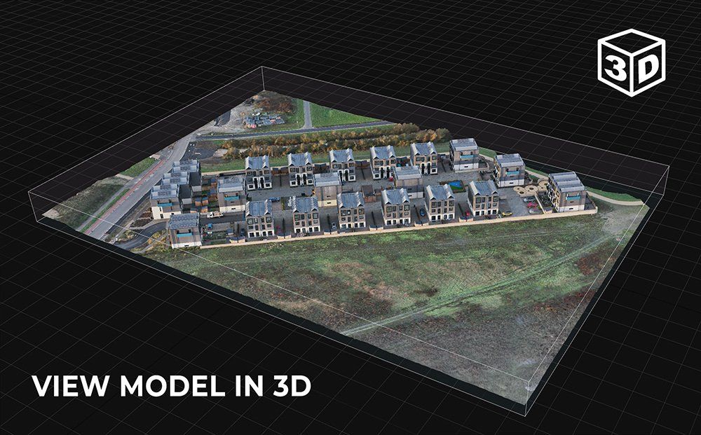
Interactive 3D Model
Created from over 2500 drone images, this example high resolution 3D model of a modular housing development, was created using one of our enterprise drones with RTK positioning to ensure that, as well as providing exceptional visual fidelity, the geometry underpinning it is incredibly accurate.
Examples of how 3D digital twin models can be used include the following applications:
- Marketing and advertising: 3D models can be used to create engaging and interactive marketing material.
- Education and training: 3D models can be used to create virtual learning material and environments.
- BIM, CAD and GIS: High accuracy meshes and point clouds allow for closer inspection and integration into many popular construction software packages.
- Visualization and design: 3D models can be used to visualise and design products, buildings, and other objects. As shown below, they can also be used to create photorealistic renderings, animations, and interactive 3D experiences.
- Gaming: 3D digital twin models can be imported as environments and objects into video games as digital assets.
- Construction: Models can be used for progression monitoring, inspection or as a visual presentation to staff in remote locations.
Cost Effective Solutions
Highly efficient capturing process, same-day data delivery, accurate and repeatable data sets.
Security
AES-256 Live data encryption during operation between drone and controller. In addition all data relating to flights and captured media is encrypted on the drone itself.
Safe and Non-Intrusive
Comprehensive pre-site planning, qualified and insured operators, low-noise operating drones.
Dependable Technology
Operations utilise the latest enterprise level drone technology used across many sectors around the world.
Accurate Data
All data is georeferenced using a combination of precision RTK, GCPs and ground level GPS equipment.
UK Coverage
Operations can be tailored to fit time-sensitive projects. Most areas of the UK can be achieved within the same working week.
Creating Detailed 3D Digital Twin Models and Maps
Employing drone photogrammetry to capture hundreds—or even thousands—of high-resolution images from multiple angles, and by extracting millions of precise point measurements from these overlapping photographs, our specialist software generates survey-grade 3D models that faithfully represent your asset. These digital twin models serve as immersive, interactive replicas of real-world objects, offering powerful insights and capabilities.
What Are Digital Twins?
Digital twin 3D models are virtual representations of physical objects, environments, or systems, created using advanced 3D modelling software and computational tools. They enable you to:
- Visualise every aspect of your asset in a realistic, navigable environment.
- Analyse structural integrity, potential issues, and performance metrics in a risk-free virtual space.
- Simulate various operational scenarios or environmental conditions, identifying potential problems before they arise.
- Optimise design, maintenance, and resource allocation through data-driven insights and predictive modelling.
The Science of Photogrammetry in Drone Mapping and 3D Modelling
Photogrammetry is a specialised branch of remote sensing that extracts precise measurements and spatial information from overlapping photographs.
By capturing images from multiple viewpoints, specialised software can reconstruct detailed 2D maps and 3D models of terrain, structures, and other objects. This process relies on triangulation: the software identifies common features in overlapping images and uses geometric principles to pinpoint their exact positions in three-dimensional space.
At
SkyTech Cambridge, we specialise in drone-based photogrammetry to deliver accurate, high-resolution spatial data. Our fleet of drones is equipped with advanced sensors and stabilised cameras, ensuring we capture crisp, overlapping images from precisely planned flight paths. We then process these images with state-of-the-art photogrammetry software, generating:
- High-Resolution Orthomosaics – Seamlessly stitched aerial images free of perspective distortion.
- 3D Surface and Terrain Models – Detailed digital reconstructions that support everything from volumetric calculations to site planning.
- Accurate Measurements – Precise distance, area, and volumetric measurements, underpinned by geospatial accuracy and optional ground control points or RTK/PPK corrections.
Using LiDAR-Equipped Drones for High-Accuracy Surveys
LiDAR (Light Detection and Ranging) is a powerful remote sensing technology that uses pulses of laser light to measure distances, enabling the creation of highly detailed 3D maps and models.
Using a specialised drone payload, a LiDAR sensor emits thousands of laser pulses per second, each of which reflects off surrounding objects, terrain, or structures. By measuring the time taken for the laser pulses to return, the system can calculate precise distances and construct a dense point cloud of the surveyed environment.
We offer advanced drone-based LiDAR surveys tailored to a wide range of industries and applications. Our expert team ensures that every mission is planned and executed to deliver the highest possible data quality. Whether you’re monitoring construction progress, assessing environmental changes, or conducting a heritage site survey, we provide precise, actionable insights that support informed decision-making.
For more information on how our LiDAR services can enhance your project, please contact us. We’re here to help you capture the data you need—safely, efficiently, and with uncompromising accuracy.
Aerial Topographic Surveys
We use advanced drone technology to deliver high-accuracy topographical surveys for a wide range of applications. By capturing comprehensive aerial imagery—often augmented with LiDAR or photogrammetric techniques—we create precise 3D representations of landscapes and structures. These models form the backbone of reliable site assessments, land development strategies, and engineering design workflows.
We begin by meticulously planning each drone flight path using geospatial software, incorporating Ground Control Points (GCPs) where necessary to enhance positional accuracy. Once on site, our drones—equipped with high-resolution sensors and LiDAR—collect detailed information on terrain, vegetation, and built features.
After the flight, our software fuses millions of data points into a precise digital surface model (DSM) or a digital terrain model (DTM), capturing contour lines, elevations, and other essential measurements.
Finally, we rigorously align all datasets with real-world coordinates, cross-referencing them against GCPs and GNSS mobile station data to ensure survey-grade accuracy.
High Quality Deliverables -
- Detailed Contour Maps – Easily identify elevation changes and gradients for planning and civil engineering tasks.
- Orthomosaic Imagery – High-resolution overhead images that provide an undistorted, true-to-scale representation of the surveyed area.
- Digital Surface & Terrain Models – 3D models that distinguish between ground elevations and above-ground features like buildings and trees.
- Fully Compiled CAD Drawings – Comprehensive survey data, complete with layers and annotations, exported in industry-standard CAD formats (e.g., DWG, DXF) for seamless integration into your engineering or GIS workflows.
Interested in how our technology can help your business?
We would love to discuss how we can support you with your next project. Feel free to get in touch for an initial informal discussion about your requirements or if you have any questions.